m (→La Pedriza) |
m (→Sierra de Madrid) |
||
| (19 intermediate revisions by one user not shown) | |||
| Line 1: | Line 1: | ||
= Sierra de Madrid = | = Sierra de Madrid = | ||
| − | La '''''Sierra de Guadarrama''''', commonly known as the ''Sierra de Madrid'' is the collection of [[mountains]] surrounding [[Madrid]] from the north, which was the reason why the [[Spanish]] capital was founded, by the Muslims, to survey the Sierra itself! It is part of the ''[[Sistema Central]]'', where it sits between the | + | La '''''Sierra de Guadarrama''''', commonly known as the ''Sierra de Madrid'' is the collection of [[mountains]] surrounding [[Madrid]] from the north, which was the reason why the [[Spanish]] capital was founded, by the Muslims, to survey the Sierra itself! It is part of the ''[[Sistema Central]]'', where it sits between the Sierra de Malagón and the Sierra de Somosierra in its strictest definition but also includes them along with the Sierra de Aylón in its widest acceptation where it becomes the neighbour to the mighty [[Sierra de Gredos]]. |
| − | <center><wz tip="Madrid as seen from its sierra (in the background on the right, the smaller city before | + | <center><wz tip="Madrid as seen from its sierra (in the background on the right, the smaller city before the big one is Soto del Real), on 14 June 2020.">[[File:sierra-Madrid-collado-najarra-14Jun20.jpg|650px]]</wz></center> |
'''[[Hiking in la Sierra de Madrid]]''' is our main [[walking]] activity in [[Spain]]. | '''[[Hiking in la Sierra de Madrid]]''' is our main [[walking]] activity in [[Spain]]. | ||
| − | + | __TOC__ | |
| − | + | <center><wz tip="Artistic view of the Sierra de Guadarrama (Zona central).">[[File:Mapa-Sierra-Madrid.jpg|650px]]</wz></center> | |
| − | + | == [[La Pedriza]] == | |
| − | + | ||
| − | + | La Pedriza is such an important part of the Sierra de Madrid that we have a [[La Pedriza|dedicated page]] for it. | |
| + | |||
| + | <gallery perrow=3 widths=200px> | ||
| + | File:ElEscorial-Abantos-26June20-6.jpg|View from the [[Hiking_in_la_Sierra_de_Madrid#Flanks_of_the_Abantos|flanks of the Abantos]]. | ||
| + | File:Pedriza-from-inside-22May2022.jpg|La Pedriza from inside ([[Hiking_in_la_Sierra_de_Madrid#Puente_de_los_Pollos|Puente de los Pollos]]). | ||
| + | </gallery> | ||
| + | |||
| + | == Zona central == | ||
| + | |||
| + | <gallery perrow=3 widths=200px> | ||
| + | DosHermanas_hike-22June20-7.jpg|Cerro de Valdemartin from [[Hiking_in_la_Sierra_de_Madrid#Pe.C3.B1a_Citores.2C_Las_dos_hermanas_y_Pe.C3.B1alara|Peña Citores]]. | ||
| + | </gallery> | ||
== La Mujer Muerta == | == La Mujer Muerta == | ||
| Line 22: | Line 33: | ||
In [[Provincia de Segovia]] y [[Comunidad de Madrid]] (Siete Picos, 2138 m). | In [[Provincia de Segovia]] y [[Comunidad de Madrid]] (Siete Picos, 2138 m). | ||
| + | |||
| + | <gallery perrow=3 widths=200px> | ||
| + | DosHermanas_hike-22June20-5.jpg|Characteristic shape confirmed from the ''peakfinder'' application (from [[Hiking_in_la_Sierra_de_Madrid#Pe.C3.B1a_Citores.2C_Las_dos_hermanas_y_Pe.C3.B1alara|Peña Citores]]). | ||
| + | </gallery> | ||
== La Maliciosa == | == La Maliciosa == | ||
In Madrid (Maliciosa, 2227 m). | In Madrid (Maliciosa, 2227 m). | ||
| + | |||
| + | <gallery perrow=3 widths=200px> | ||
| + | File:Maliciosa-13Sept20-12.jpg|[[Hiking_in_la_Sierra_de_Madrid#La_Maliciosa|Taming the Maliciosa]], in September [[2020]]. | ||
| + | </gallery> | ||
| + | |||
| + | == La Bola del Mundo == | ||
| + | |||
| + | <gallery perrow=3 widths=200px> | ||
| + | File:DosHermanas_hike-22June20-6.jpg|View from the [[Hiking_in_la_Sierra_de_Madrid#Pe.C3.B1a_Citores.2C_Las_dos_hermanas_y_Pe.C3.B1alara|Peña Citores]]. | ||
| + | File:ElEscorial-Abantos-26June20-5.jpg|View from the [[Hiking_in_la_Sierra_de_Madrid#Flanks_of_the_Abantos|flanks of the Abantos]]. | ||
| + | File:Sierra-de-Madrid-Pedriza-May22-1.jpg|From the heart of [[la Pedriza]], [[Hiking_in_la_Sierra_de_Madrid#Yelmo_and_Tolmo|on our way to el Yelmo]], on {{thisday|1|May|2022}}. | ||
| + | </gallery> | ||
== Cuerda Larga == | == Cuerda Larga == | ||
| Line 49: | Line 76: | ||
== Sierra de Canencia == | == Sierra de Canencia == | ||
| − | In Madrid | + | In the [[Comunidad de Madrid]], overlooking [[Canencia]] and [[Guarganta de los Montes]]. Main peak: Mondalindo, 1831 m. |
| + | |||
| + | <gallery perrow=3 widths=200px> | ||
| + | File:SierraCanenciaDesdePuerto-May22.jpg|La Sierra de Canencia as approached from the Puerto de Canencia, here from the [[Hiking_sierra#Cabeza_de_la_Bra.C3.B1a|Cabeza de la Braña]] on 14 May 2022. | ||
| + | </gallery> | ||
== Sierra de la Cabrera == | == Sierra de la Cabrera == | ||
Latest revision as of 09:44, 28 May 2022
Sierra de Madrid
La Sierra de Guadarrama, commonly known as the Sierra de Madrid is the collection of mountains surrounding Madrid from the north, which was the reason why the Spanish capital was founded, by the Muslims, to survey the Sierra itself! It is part of the Sistema Central, where it sits between the Sierra de Malagón and the Sierra de Somosierra in its strictest definition but also includes them along with the Sierra de Aylón in its widest acceptation where it becomes the neighbour to the mighty Sierra de Gredos.

Hiking in la Sierra de Madrid is our main walking activity in Spain.
Contents |

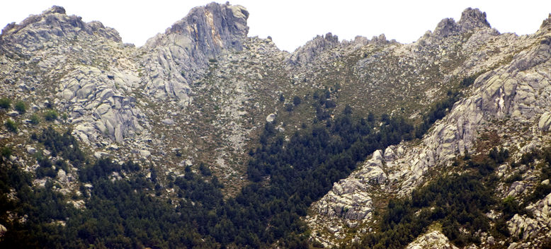
La Pedriza
La Pedriza is such an important part of the Sierra de Madrid that we have a dedicated page for it.
View from the flanks of the Abantos.
La Pedriza from inside (Puente de los Pollos).


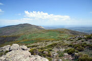
Zona central
Cerro de Valdemartin from Peña Citores.

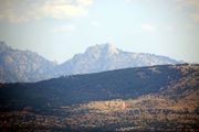
La Mujer Muerta
In Provincia de Segovia (La Pinareja, 2197 m).
Siete Picos
In Provincia de Segovia y Comunidad de Madrid (Siete Picos, 2138 m).
Characteristic shape confirmed from the peakfinder application (from Peña Citores).

La Maliciosa
In Madrid (Maliciosa, 2227 m).
Taming the Maliciosa, in September 2020.

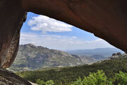
La Bola del Mundo
View from the Peña Citores.
View from the flanks of the Abantos.
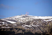
From the heart of la Pedriza, on our way to el Yelmo, on 1 May (2022).


Cuerda Larga
In Madrid (Cabeza de Hierro Mayor, 2383 m).

Sierra de Malagón
In Ávila, Madrid y Segovia (Cueva Valiente, 1903 m).
Sierra de la Morcuera
In Comunidad de Madrid (La Najarra, 2122 m).

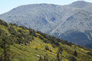
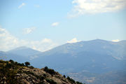
Sierra de Canencia
In the Comunidad de Madrid, overlooking Canencia and Guarganta de los Montes. Main peak: Mondalindo, 1831 m.
La Sierra de Canencia as approached from the Puerto de Canencia, here from the Cabeza de la Braña on 14 May 2022.

Sierra de la Cabrera
In Madrid (Cancho Gordo, 1564 m).

Gallery

Links