m (→Plaza Mayor) |
m (→Gallery) |
||
| Line 24: | Line 24: | ||
Vintage (credits unknown). | Vintage (credits unknown). | ||
| − | < | + | <gallery widths=200px perrow=3> |
| + | File:PlazaMayor1933.jpg|Aerial view from 1933. | ||
| + | File:plaza-mayor-arboles.jpeg|Same but wider perspective. | ||
| + | </gallery> | ||
== Links == | == Links == | ||
Latest revision as of 07:26, 28 May 2021
Plaza Mayor
La plaza Mayor is the heart of Madrid. It is 129m×94m in size.
Its location was right at the outskirt of the old city (Mayrit), when the Muslims ruled it. There was then damps, possibly a river. When the city expanded, it became a market and then the Plaza del Arrabal, which was a popular spot, both messy and unsanitary. Felipe II asked for its reform (in 1577). The construction started only under Felipe III's reign (in 1617). The Plaza Mayor as it is known today dates from 1790, as modelled by the architect Juan de Villanueva. It got several names, before taking the only one that does it justice and , namely, it was first the Plaza del Arrabal, then Plaza de la Constitución, Plaza Real, Plaza de la República, Plaza de la República Federal, Plaza de la República Democrática Federal and as a slap of all the previous names, the Plaza de Calvo Sotelo (under Franco).
The timelapse below shows the Semana Santa MMXIV edition, which we captured from our flat:
Gallery
Aerial views (credits unknown).


Vintage (credits unknown).
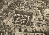
Aerial view from 1933.
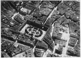
Same but wider perspective.

